STOP
5
Excellent roadcut exposures are
available at the intersection
of Anderson Ave. and Scenic Drive. This locality displays the
stratigraphic interval from the top of the Neva Limestone Mbr. of the
Grenola Limestone through the Bader Limestone. Of special
interest is the Eskridge Shale and the Beattie Limestone.
Detailed descriptions of this stratigraphic section can be found in
Miller and West (1993).
The Eskridge is a variegated mudstone
with extensive paleosol
formation, interrupted by two intervals of shallow marine calcareous
facies. Joeckel (1991) described the same pattern of paleosol
development and marine flooding in southern
Nebraska. The lower paleosol interval of the Eskridge is
characterized by the spectacular development of stacked horizons of
elongated carbonate nodules (Fig. 23). These are locally
tightly packed and take on the appearance of a prismatic ped
structure. The carbonate precipitation was likely controlled
primarily by roots (ie. the nodules represent rhizocretions), but the
influence of burrowing cannot be discounted (Fig. 24).
Lungfish and other vertebrate burrows have been recognized at other
localities within the lower Eskridge. The thin limestone beds
that overly this paleosol interval are characterized by a molluskan
fauna dominated by pectinid and myalinid bivalves.
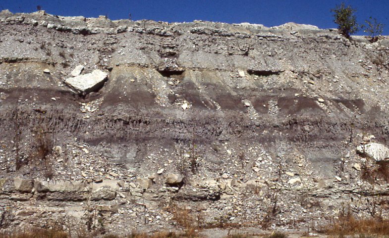
Figure 23. Lower Eskridge Shale displaying paleosol horizons with
prominent elongated carbonate nodules overlain by thin shallow marine
molluscan limestones.
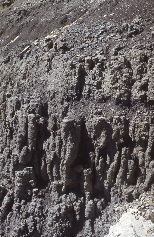
Figure 24. Close-up closely packed elongated carbonate concretions
associated with paleosol horizons of the Eskridge Shale. These were
likely influenced by roots or possibly burrows.
Above the Eskridge is the prominent
Beattie Limestone. The transgressive surface at the base of
the Beattie is marked by a well-developed intraclastic bed with
phosphate nodules, bone fragments, and skeletal debris. The
Beattie Limestone has been intensively studied across the Kansas
outcrop belt (Imbrie, 1955; Laporte, 1962; Imbrie et al.,
1964). The Cottonwood Limestone member has a lower bioclastic
facies with abundant algal-coated grains and an upper fusulinid
facies. Overlying the Cottonwood is the Florena Shale Mbr.
with abundant Derbyia and Neochonetes brachiopods.
STOP
6
The Scenic Drive roadcuts provide a
continuous exposure from the Bader Limestone of the Council Grove Group
through the Wreford Limestone of the Chase Group. This
locality provides an excellent opportunity to see five uninterrupted
cyclothems and their internal meter-scale cycles. The
intraclastic beds marking the cyclothem-bounding transgressive surfaces
are easily recognized. A detailed description of this
complete stratigraphic section is provided in Miller and West
(1993). The brief discussion below will focus on the interval
from the Crouse Limestone through the Wreford Limestone.
The Crouse Limestone has been
interpreted as recording a shallowing-upward transition from a shallow
subtidal to a supratidal environment (West & Twiss,
1988). The lower Crouse is a wackestone to packstone
characterized by pyramidellid gastropods and bivalves. By
contrast, the upper Crouse is a thin-bedded, horizontally laminated,
dolomitic micrite with small evaporite molds and pavements of
ostracodes.
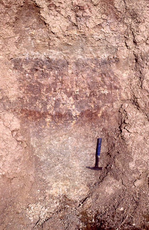
Figure 25. Lower paleosol horizons of the Blue Rapids Shale. In this
photo can be seen the reddish B horizon with carbonate caliche nodules
and rhizocretions, and the C horizon below. The paleosol is sharply
truncated at the top by laminated calcareous shales deposted by a
marine flooding event.
Above the Crouse is the Blue Rapids
Shale with three stacked paleosol profiles each truncated by a flooding
surface (Fig. 25). These paleosols show again the common
pattern of calcic paleosols overlain by vertic profiles.
Separated from the Blue Rapids by the thin Funston Limestone is the
Speiser Shale. The Speiser at this locality consists of a
series of stacked and truncated paleosol profiles giving the outcrop a
striking "barber pole" appearance (Fig. 26). These red and
green stacked horizons are followed by a greenish-gray vertic profile
with well-developed pseudoanticles and large root molds.
Interestingly, when the Speiser is traced to the east toward the axis
of the Nemaha Anticline it thins and the lower stacked paleosols are
replaced by a single well-developed profile. This suggests
that the Nemaha was a stable topographic feature at the time with
periodic sediment influx burying soils in slightly lower
areas. Lateral changes in the Speiser and Blue Rapids Shales
are illustrated in Miller and West (1998). Importantly, in
both cases the meter-scale cycles can still be traced over at least
tens of kilometers.
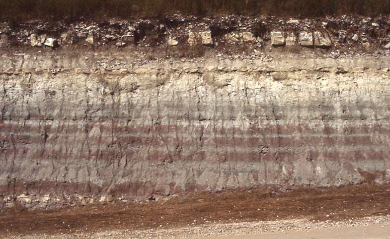
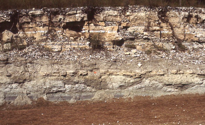
Figure 26. The upper image shows the Speiser Shale with the lower
“barber pole” interval of thin truncated paleosols overlain by a vertic
paleosol. The undulatory pseudoanticlines of the vertic paleosol are
well displayed in the lower image. The vertic paleosol is overlain by
the cherty Three Mile Limestone member at the base of the Wreford
Limestone.
The facies of the Wreford Limestone have
been studied in detail by Hattin (1957) along the full extent of the
Kansas outcrop belt. The Wreford has regionally prominent
cherty limestone members at its top and bottom.
These limestones contain diverse marine faunas including productid
brachiopods, bryozoans and crinoids. The origin of the chert
remains unresolved, although some appears to have replaced burrow
structures and some has replace evaporite nodules. The latter
are represented by isolated nodules of radial length-slow chalcedony
(Folk & Pittman, 1971). Between the two cherty
limestones is the Havensville Shale Mbr., an interval of gray to
yellowish-gray mudstone (Fig. 27). This unit is noteworthy
for two reasons. Firstly, very well-developed boxwork
structures are present near the middle of the unit (Fig.
28). These structures are rather common within the Lower
Permian section and usually appear to record periods of subaerial
exposure under rather evaporitic conditions.
Secondly, overlying the boxworks is an interval with abundant large
cauliflower-shaped geodes. These appear to be the result of
the replacement of anhydrite nodules (Chowns & Elkins, 1974).
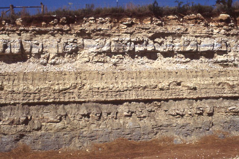
Figure 27. The Havensville Shale Member and overlying Shroyer Limestone
Member of the Wreford Limestone.
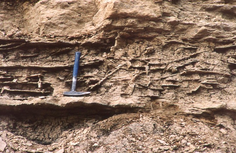
Figure 28. The middle of the Havensville Shale Member displaying
well-developed boxwork structures. These calcite-filled fractures are
likely related to arid evaporitic conditions.
CONTINUE
KANSAS FLINT HILLS GEOLOGY
NEXT